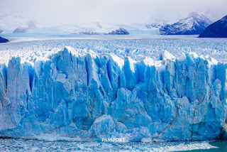
Glaciers are one of the major geological agents. They are responsible for a great erosion. Glaciers can transport huge blocks of rock that no other erosive agent would be capable of. In times of great planetary glaciations, its modeling of the landscape was of great importance and its traces are observable in nature. However, glacial action only occurs in polar regions and high mountains.
GLACIERS ERODE THE LAND IN TWO MAIN
WAYS:
1.-
PLUCKING: when the glacier flows across the
land, its water enters cracks in the bedrock, freezes and expands. Then that
frozen water softens and fractures those rocks, lifts them up and incorporates
them into the ice of the glacier. In this way, sediments of all sizes form part
of the glacier load.
2.-
ABRASION: As the glacier and all its rocky load
move across the surface, it "sands" and smoothes the entire surface
below. The rock that is pulverized is known as "rock flour". If the load of rock carried by the glacier
is very large, it can produce grooves on the surface that are called "crevasses".
https://slidetodoc.com/presentation_image_h/279d28b4457419de84868f4303a9f2fa/image-11.jpg
The EROSION VELOCITY is influenced by four factors: 1.- Glacier movement
speed. 2.- Ice thickness. 3.- Shape, abundance and hardness of the rocks contained
in the glacier. 4.- Erosionability of the surface below the glacier. The variability of these factors determines the degree of erosion and modification carried out by glaciers in natural landscapes. |
LANDSCAPES AND FORMS PRODUCED BY
EROSION:
The topography generated by a valley glacier is sharper and more angular,
while cap glaciers smooth the terrain.
Among the forms generated we can point out:
/
U-shaped glacial valleys: The glacial tongue creates a U-shaped valley, unlike
rivers that create a V-shaped one. The enormous erosive force of the ice
deepens and widens the valley.
/ Truncated
Spurs: The force of the ice erodes and removes the earthen
spurs from the valleys. The result of this erosion are triangular shaped
cliffs. https://mammothmemory.net/images/user/base/geography/truncated-spur-in-geography-2.6079ebe.jpg /
Hanging valleys: when the glaciers recede, the valleys of the tributary
glaciers are above the main glacial depression. This is a hanging valley, in
which rivers usually flow that form waterfalls. https://www.coolgeography.co.uk/GCSE/Year%2010/PhysicalWorld/Glacial%20Landforms/hangingvalley.jpg /
Rosary lakes: they are depressions produced by the erosive force of the glacier, which
fill with water and give rise to small separate and interconnected lakes along
the glacial valley. |
https://news.climate.columbia.edu/wp-content/uploads/2018/07/2018-07-14-15.09.31-637x478.jpg
/
Fjords: They
are deep inlets, with steep slopes, which have been produced by glacial erosion
in mountain areas near the ocean. They were generated once the ice left those
valleys and the sea level rose from the Quaternary period. Glaciers are capable
of continuing to erode the valley below sea level.
https://es-academic.com/pictures/eswiki/71/Geirangerfjord_%286-2007%29.jpg
/ Cirques: It is the depression that forms at the head of the
glacier where the snow accumulates and turns into ice. It is shaped like a bowl
with steep walls on three sides and a fourth that is open and through which the
valley would descend. When the glacier disappears, a lake called a “tarn” forms
here.
https://i.pinimg.com/originals/d9/bf/28/d9bf285bfcd9f1e5aaba875eec4fc6e8.jpg
/
Steep slopes: These are sinuous ridges with sharp edges produced by the erosive action
of the glacier.
https://www.thepassport.travel/images/gallery/5911
/ Sheep Rocks: These are hills with a gentler slope on one side and a
steeper slope on the opposite side. They indicate the flow that the ice has
followed. The gentle slope has been produced by the erosive flow of the ice and
the steep one by a removal of the substrate from that area.
https://s0.wklcdn.com/image_12/374149/4665286/2353134Master.jpg
/ Mountain
passes: when there are 2 glaciers on opposite sides of a
mountain, the crest that remains in their cirques is eliminated and sometimes a
passage from one valley to another is created.
https://upload.wikimedia.org/wikipedia/commons/thumb/9/94/Andermatt-Teufelsbruecke.jpg/220px-Andermatt-Teufelsbruecke.jpg


.jpg)
.jpg)


